Today I will be observing the major impacts on climate change throughout the world and specifically in Nepal. Worldwide there are three major impacts that have taken place due to climate change. First, there are the physical systems that are affected, which include all of the physical attributes of the Earth. In cold regions glaciers, snow, ice and or permafrost are affected. In mild climates rivers, lakes, floods, and or and floods are fluctuating. Next there are the biological systems that take effect to climate change. This includes terrestrial ecosystems, wildfires, and marine ecosystems. Lastly there are the human and manages systems like food production, livelihoods, health and economics. In the Asian region that Nepal lies in there are currently three major key risks due to climate change. There has been an increased riverine, coastal, and urban flooding which has caused widespread destruction due to infrastructure, livelihoods, and areas of population in Asia. There is a heightened risk of heat-related mortality. In addition to these two risks there is also an increased worry about drought-related water and food shortage leading to malnutrition.
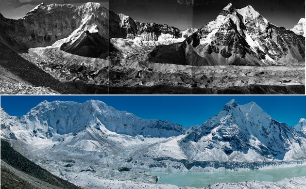
(melting of the Himalayan region)
Next, I observed the region of South Asia's projected and current climate changes using the IPCC's database. All of these observations are based off of physical science basis's. In recent years decreased precipitation has been observed along the Indian monsoon trough, compared to years past. It could be due to any number of reasons, but scientists are claiming it is an effect of black carbon, and sulphate aerosols. Projections for the future include a rise in temperature and a strong seasonality change. The largest concern with the projected temperature increase is the melting of the Himalayan region. In addition to rivers flooding and effects from the melting, the increased temperatures will strengthen summer monsoons which will create extreme rainfalls.
Looking deeper into the effects of climate change in Asia as a whole, there are many factors that could contribute to its environmental degradation. There is a concern of droughts and water scarcity due to the poor management of water systems in Asia. Water will also be hard to find due to the increasing population and climate changes. It is predicted that areas with heavy poverty will not be able to adapt time for the environmental changes to come. There will be fewer growing periods for the cash crop of rice, due to the increase in heat waves. In addition to fewer growing days, the population and well being of Asia as a whole will suffer from heat waves. With sea level projected to significantly rise, low level cities will be in danger. With the heat waves, and increasing temperature malaria, dengue fever, and diarrhea outbreaks are predicted to increase. Along with the rising sea levels, increased precipitation will cause flooding, mostly affecting areas with poverty, or non-developed areas. The largest concern is the undeveloped and less up to date regions of Asia, will take the hardest hits to the climate change. On the other end of the spectrum it is encouraged that larger cities take action to have more sustainable development plans to help reverse the affects of climate change.
source
( Nepal is at high risk)
The most interesting threat I found was the change in the distributions of species and biomes. There will be trees invading treeless vegetation, and a rising CO2 level will increase evergreen forests. While all of this is taking place the tundra will rapidly decrease due to an increase in precipitation. A projected decline in bat species is a threat to many different types of bats, because of the vegetation and ecosystems they thrive off of. Species that are limited to the specific region they thrive in will be at risk the most, because they cannot escape or adapt fast enough. I find this topic interesting, because we are so used to what the Earth is to us, it is hard to imagine that it would change. I feel like in our generations lifetime we will witness a vast change in the Earth's environment, and we can be a part of making the change a positive one. In terms of this topic, I think that change with topography and the vegetation, and species of the Earth is inevitable. Things evolve constantly adapting to new changes, while it may wipe out certain species, that has already been happening the Earth's whole lifetime.
Thursday, December 4, 2014
Wednesday, November 19, 2014
severe weather in Nepal
Today we will take a look at severe weather on a global and local point of view in Nepal. Tornadoes form because of several different factors, but they start out because of strong westerly winds flowing aloft and southeasterly surface winds flowing below. This causes a vertical wind sheer, making a rotating body of air. This horizontal body of air is then lifted off of the surface by the updraft of a thunderstorm. If the horizontal air mass is lifted to a vertical position it is considered a mesocyclone. At the point of the actual tornado making contact with the ground it becomes a funnel cloud that descends through the wall cloud. Looking at the United States specifically tornados tend to travel from west to east. This is because tornados usually form in the mid-latitude hemisphere, where the westerlies blow the storms west to east. Focusing back on Nepal, we can find that Nepal lies in the area of south-eastern Asia that has an attractive climate for tornadoes. However, Nepal itself has no recorded data of experiencing a tornado they occur above and below it in India and South China. (source)
The United States experiences an average of 1,200 tornadoes annually. (source) Due to lack of meteorological equipment in Nepal, I was unable to find the average of tornadoes let alone tornadoes recorded at all.
In relation to this global map of tornado prone areas, Nepal is in the mid-latitude hemisphere of the globe. This makes it a target for severe thunderstorms, which leads to possible tornadoes. Cold, dry air tends to spill over the Himalayas, mixing with the warm moist air in the wet monsoon seasons which creates unstable air. I believe that the increased amount of tornadoes in the past 30 years is due to the climate change of the earth. The global heating that has been occurring creates more instability in the air, and warms the winds and oceans making it easier for storms to form.
Next, we're going to compare a different storm that occurs in the U.S and globally, the hurricane.
It takes three main components to strike a hurricane. First you have to have an ocean temperature of 80 degrees or more, to get a lot of evaporation happening. In addition to the warm ocean temperature it needs to go deeper than the surface, in fact try a depth of 200m. This ensures that when the strong winds are chopping up the water you still have warm water throughout no matter what. To create a hurricane you usually need to be between >5 degrees north or south. This allows coriolis to initiate the spinning of the storm, so that it can travel. Nepal happens to lie at 26.5 degrees north of the equator making it perfect for hurricanes. Hurricanes in the United States usually strike southern states like Texas, Louisiana, and Florida including the states above them, and East coast states. This is because they rest near warmer oceans closer to the equator. Hurricanes have been known to strike Hawaii as well. To look at a more global viewpoint on hurricanes, there are three main formation regions, and each zone calls them by different names. In the Atlantic and the East pacific they are called Hurricanes. In the Indian Ocean and near Australia they are called tropical cyclones. Off the coasts of China, Indonesia and Japan they are called Typhoons.
Hurricanes tend to travel in a curve along the east coast after they have done their damage due to the warm waters of the gulf stream running along the east-coast, being pushed along by the east-westerly winds and the jet stream. Annually 5-6 hurricanes strike the U.S. source Although I was not able to find a database of recorded hurricanes for Nepal it has had a couple severe ones that stood out in articles I found. The tropical cyclone "Hudhud" hit Eastern India this year and traveled over to Nepal causing blizzards in the Himalayas and flooding from all the rain. source
Wednesday, November 5, 2014
Daily Weather in Nepal
This week we'll be diving into a typical three day forecast for this time of year in Nepal's capital city, Kathmandu. I looked at Kathmandu's forecast for 11/5/14-11/7/14. On Wednesday the 5th the forecasted high is 70 degrees with a low of 53 degrees Fahrenheit. The precipitation percentage for the 5th is 50% with a good chance for light showers. Progressing to Thursday the 6th there is a forecasted high of 72 degrees, a low of 52 degrees Fahrenheit and a chance of precipitation at 6%. Finishing up on Friday the 7th there is a forecasted high of 77 degrees, a low of 53 degrees Fahrenheit, and a precipitation percent of 4%. Over the three day period there was an average pressure of 30 inches, with no change in pressure. The average wind speed is predicted to be 4.6 mph, with a steady unchanging speed over the three day period. Overall, it will be a pretty similar three days this week Wednesday through Friday, so worry free weather is on the way.
Above you can observe a satellite image from a little earlier than this post will be published. There are clouds in the Himalayan mountain region just north of Kathmandu. They are relatively far but in respect to proximity to the mountains they are fairly close. They are a mix of cold clouds near the summits of the mountains, while at the bases of the mountains there are low and warm clouds. This can be observed by noticing that the cold clouds are blue while the low warm clouds are grey and white. From what I could observe on the radar portion of the satellite image there was no precipitation in the Kathmandu region at this point in time. The surface characteristics of Kathmandu itself are mostly forest and parks. It is in a circular shape placed in the middle of hills and mountains. In the middle of the circular shape of Kathmandu lies cityscape with bridges over local rivers like the Bishnumati, Bagmati, and Manohara rivers that run throughout the city.
Looking at the large-scale regional pattern of low and high pressure and fronts for Kathmandu, we can look at Asia as a whole. There is a large high pressure system Northeast of Nepal that keeps the weather mild a majority of the time. South of Nepal there is a low pressure system in the Indian Ocean. To the West of Nepal there is a cold front along with a stationary front northwest of Nepal. The warm moist air from Nepal's subtropical climate circulates into the stationary front while thunderstorms and showers can occur near the cold front. In the center of Nepal there is a High pressure system assuring mild seasons.
The closest small-scale surface analysis map to Nepal is India. Being located between India and China Nepal is effected by both large regions pressure systems.The low pressure system in the Indian Ocean reading at 100mb does have an onshore effect to Nepal with an extending isobar of 1012mb. This low pressure system is the source of the Asian Monsoon. This usually ends up being the only substantial weather occurrence during Kathmandu's year.
Tuesday, October 28, 2014
Global and local winds in Nepal
Today I decided to look into Nepal's location and how it relates to global winds. Nepal lies at a longitude of 26.5333° N and, a latitude of 86.7333° E in the northern hemisphere. In terms of atmospheric cells, Nepal is in the Hadely Cell. The North East trade winds or the "tropical easterlies" blow across the country. This brings on winter monsoons. Nepal lies in-between the subtropical high pressure belt and the equatorial low, however an area of low pressure resides in Nepal. Being landlocked in the tropic of cancer, Nepal is located just below the horse latitudes.
Nepal has wet summers and dry winters being located in the Tropic of Cancer. Nepal's location is unique being located in-between a pocket of sinking air and rising air. Asian monsoons are brought on in the summer time due to the thermal low located just above Nepal. Warm air from the Indian ocean flocks to the thermal low, creating heavy precipitation during the summer season. On the other hand, in the winters are fairly mild because of the Siberian high located above Nepal in January. The north-east trade winds blow in the leeward across the country.
Nepal has substantial mountains, including Mt. Everest the tallest mountain in the world. The Himalayan mountain range extends across the country from the eastern edge to the western edge, also called the Parbat region in Nepali. When thinking about mountain breezes they are usually associated with the katabatic wind, Chinook wind, the Santa Ana winds, mountain breeze, and valley breezes. Due to Nepal's many valleys and major mountain region, it experiences all these winds, except for the Santa Ana winds. The two winds associated with the ocean are the sea breeze and the reverse of that which is the land breeze. Nepal does not experience these, due to being a landlocked country.
Thursday, October 9, 2014
Typical Weather and Tourism in Nepal
In today's post I will be addressing Nepal's seasonal and astronomical events, as well as some tourism tips. First I'll start off by taking a look at a winter solstice, which is the onset for winter and marks the shortest day of the year. Due to being in the Northern Hemisphere Nepal's winter solstice takes place on December 22nd at 4:48 AM (NPT). As observed by the Nepal Bureau of Standards, Weather Meteorology, in 2005 the average maximum temperature in December is 70 degrees F. On the other hand, the average minimum temperature is 35 degrees F. Light rain, and drizzle are usually expected at this time in December. The average precipitation in December is 1mm.
The summer solstice, or otherwise called the June solstice takes place on June 21st at 4:36 PM (NPT) local Nepalese time in Kathmandu. Summer solstices mark the longest day of the year, and begin the onset of summertime. The tilt of Earth's semi-axis is most inclined towards the sun at this point in the year. Since, it's one of the more hot months June's average maximum temperature is 84 degrees F. Keeping it pleasant the average minimum temperature gets down to only 66 degrees F. In June it rains 26 days out of the month coming in at an average rainfall of 129mm. Along with the humidity during this month it can get muggy on the rainy days.
Nepal's Spring equinox occurs on March 20th, at 10:42 PM (NPT). This is a time when tourists flock to Kathmandu due to a average maximum temperature of 75 degrees F, and a average minimum of 46 degrees F. The days in March get 8-9 hours of sunshine making it a pleasant time to visit Kathmandu. The average precipitation during March is 5mm, raining 10 days out of the month. This is also an amazing time to visit due to the Holi festival influenced by the neighboring country of India. It is a religious holiday where colored powders and water are thrown all over the towns at people and things celebrating children.
Reining in the fall season the autumnal equinox took place on September 23rd at 8:14 AM. The average maximum temperature is 80 degrees F, and the average minimum temperature is 63 degrees F during the month of September. It rains about 168mm throughout the month, marking the end of monsoon season, but still continuing to rain. This is also a good month to hike with the lessening humidity and heavy cloud cover.
Come to Nepal and reach new heights!
Going more into the tourist aspect of things versus the data of the seasons, it's best overall to visit Nepal in the springtime for the best visuals of the land. During this time the national flower blooms creating a beautiful landscape. There are also clear views of the mountains during this season. However, if trekking is the reason you are in Nepal Autumn is also one of the best times because of its crystal clear skies, mild temperature, and is a season for festivals in Kathmandu. During autumn and spring hot air ballooning is a popular tourist attraction. Due to the clear skies, breathtaking views of Kathmandu valley and the Himalayan region can be seen. Not too keen on heights? Not to worry, there are plenty of national parks and wildlife reserves to keep you busy on the ground. Koshi Tappu wildlife reserve is popular for bird watching wetland species.
Wednesday, October 1, 2014
Temperature controls in the city of Kathmandu in Nepal
Nepal's landlocked position in South Asia poses many possible and interesting climate change possibilities. Since ocean currents and proximity to the ocean are out of the picture, I will be focusing on altitude, latitude, and wind direction, and geographic position as temperature controls. Nepal's capital Kathmandu lies at the latitude of 27° 43' 0" N and a longitude of 85° 19' 0" E. The warmest month is June and it's average temperature is 74.6°F. Even though it's one of the hottest months June can be a pleasant time to visit versus the winter time. The coldest month in Kathmandu is January with a monthly average temperature of 50.1°F. Based on this information I concluded that the annual range of temperature is 24.5°F. source
One temperature control that impacts Kathmandu is it's geographic position. First, Nepal itself is landlocked, and Kathmandu itself is a valley. This causes cold air to accumulate, and the valley floor is heated during the day. The warm air rises at night causing a wind through the valley cooling the average temperatures. The Kathmandu valley is bowl shaped rising 4,238 ft. above sea level, and the Shivapori, Phulchowki, Nagarjun, and Chandragiri mountain ranges surround it. On the other hand, a temperature control that doesn't affect Kathmandu is ocean currents. Due to it's high elevation and being surrounded by India and China. Although several rivers run through the valley, it's not nearly as large of an effect as ocean currents running along the coast of a country.
Like much of South Asia in general Kathmandu is subject to global warming climate changes in the future. This would imply heat waves, droughts and extreme weather events. source The nearby Himalayan glaciers could potentially melt and flood the Ganges river. However, this is very hypothetical due to recent studies stating that as of present the Himalayan region has remained unchanged, or even grown more. Due to Kathmandu's high altitude and summers full of monsoons, heavy precipitation and flooding are potential extreme events. source
In conclusion, my research on Kathmandu's temperature controls, and potential climate change have opened my eyes to how elevated the capital actually is. In addition, I discovered that Kathmandu is a valley, and is the most popular city for tourists. As a whole, Kathmandu is a very intricate valley with interesting temperature controls as opposed to flat land.
Subscribe to:
Posts (Atom)